Ten or more agencies mobilize within the day. Federal emergency management. State fire command. County sheriffs. Municipal fire crews. Utility companies. Public health. Multiple emergency broadcast systems. Every one of them is generating data. Every one of them is issuing orders. None of them are synchronized.
This is the part of a disaster response that rarely makes the news, but it’s often the part that decides how many people get hurt: the information problem. Some of what’s coming in is classified at the federal level. Some is sensitive but needs to move fast between agencies. Some must reach the public in minutes, not hours. Get that sorting wrong, and one of two things happens. The wrong information reaches the wrong people. Or the right information reaches no one at all.
The problem no single agency can solve alone
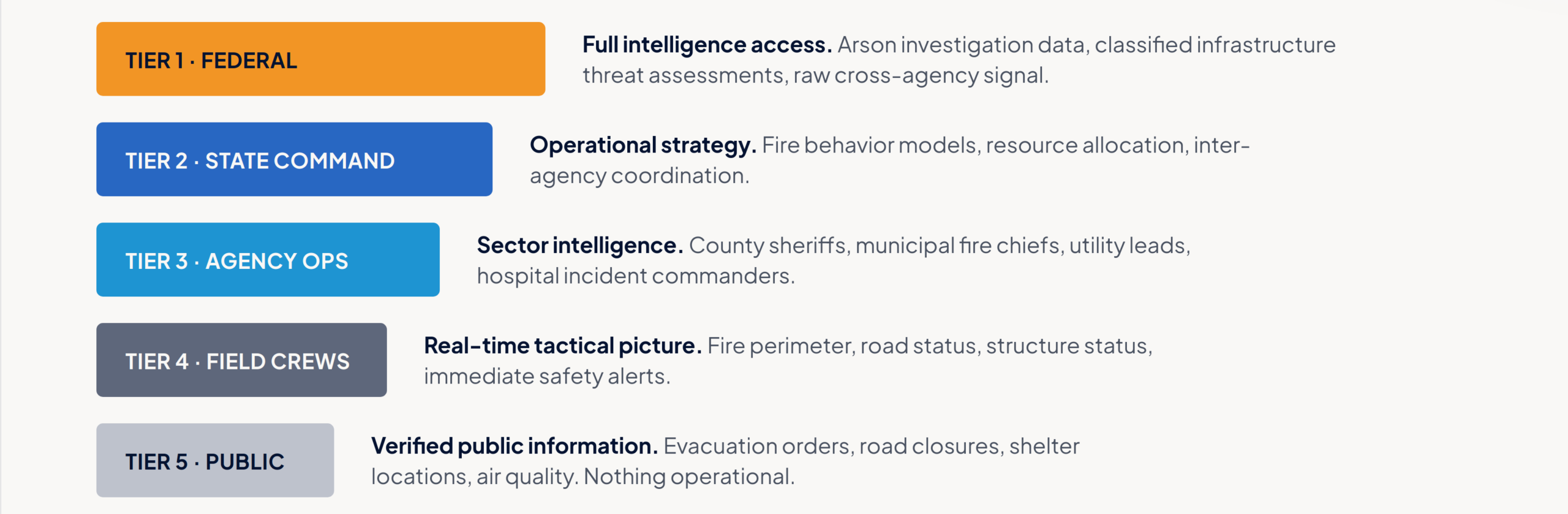
A wildfire response isn’t one operation. It’s five operations happening on top of each other, in the same three counties, drawing on the same underlying picture of the fire, but each with a different job and a different right to know.
That’s the real challenge behind a response like this one. Not just fighting the fire. Deciding, in real time and at scale, who gets to see what.
Polaris I/O is built to answer that question automatically, structuring every piece of intelligence against five access tiers and carrying that same structure through to whatever communications systems each agency already uses.
How it would play out
Here’s how that architecture would carry a response like this from ignition to containment:
Ignition. Polaris I/O pulls in satellite thermal feeds, aerial reports, ground sensors, and scanner audio from six county dispatch centers at once and resolves three conflicting sets of coordinates into one verified fire boundary within four minutes of the first report. A viral post misidentifying the origin point gets flagged and kept out of every agency feed before it can do any damage. The moment the incident is classified as major, five clearance-tiered distribution channels stand up on their own. No one has to set them up by hand.
Days 1 and 2. The fire’s spread rate triples inside a 90-minute window, and a Tier 2 alert recommends evacuating a threatened community before it reaches a two-mile proximity threshold. At the same time, the system catches something no single agency was positioned to see on its own: a hospital sitting directly in the fire’s projected path, with 340 non-ambulatory patients who’ll need coordinated transport. That flag goes out early enough to matter. Meanwhile, an arson investigation signal opens at Tier 1 only, and evacuation orders reach field crews and the public simultaneously, each getting exactly the level of detail they’re entitled to and nothing more.
Days 3 through 5. Power grid telemetry drops across 14 substations. Three shelters approach capacity, triggering an overflow recommendation before anyone has to ask for one. When cell service fails across two sectors, the system shifts to an isolated edge network without a gap in coverage. Six mutual aid crews arriving from out of state get routed to the right sector channels automatically, no dispatcher required.
Days 6 through 10. The system identifies an 82 percent probability of successful containment if crews can reach a natural ridgeline within six hours, and pushes it as the top priority action. A false report about a shelter closing spreads online and gets caught and corrected on the public channel in 90 seconds, before it changes anyone’s evacuation route. For the first time, three county incident commands operate on a single, unified Tier 2 channel.
Days 11 through 14. As the fire is contained, the system compiles the complete incident record, 14 days of signal structured by clearance tier, ready for distribution to whoever needs it. That record feeds a pattern library, so the next wildfire in this region doesn’t start from zero. Sector by sector, re-entry authorization goes out in real time as each area is cleared.
What changes when access sorts itself
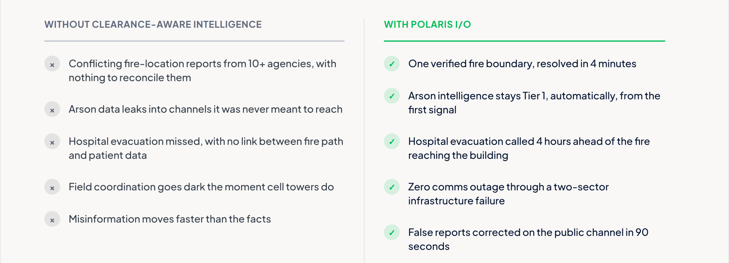
Take the clearance layer away, and here’s the version most incident commanders know too well: ten-plus agencies generating conflicting reports with nothing to reconcile them. Arson data leaking into channels it was never meant to reach, compromising an investigation before it starts. A hospital evacuation missed entirely, because nothing was linking fire path predictions to patient census data. Field coordination going dark the moment cell towers do. Misinformation moving faster than the facts. And when it’s over, no structured record for next time, so the next fire starts the response from scratch.
With it: one verified fire picture inside four minutes. Arson data that never leaves Tier 1. A hospital evacuation call made four hours ahead of the fire reaching the building. Zero comms outages through an infrastructure failure that would have taken down field coordination. Misinformation corrected in 90 seconds. And 14 days of intelligence that make the next response faster than this one.
The question worth asking
Most organizations running a multi-agency response already have the fire behavior models, the mutual aid agreements, the command structure. What they don’t always have is a layer that knows, instantly and without a person in the loop, who’s cleared to see what.
If you’ve sat inside an incident command post during something this size, you already know where the friction usually shows up. Is it the data itself? The rules about who can see it? Or just getting the right message to the right person before the moment passes?